


With ever increasing property values across the country, land that had been previously defined as floodplain is being reexamined for development. These areas are generally adjacent rivers with a connection to the natural environment offering prime real estate if the floodplain designations were removed.
What is a Floodplain?
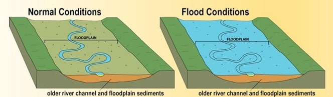
Floodplain is defined as an area of low-lying ground adjacent to a river that is subject to flooding in a major rainfall event. The area is enclosed by valley walls, which can extend many miles away from the banks of the river. Depending on the region’s climate, some of these areas only flood during a major 100-year storm while others will flood almost annually.
The extents of floodplain boundaries are based on several factors, but in floodplain analysis, can be categorized into hydrology and hydraulics.
- Hydrology is the process of determining the volume of water conveyed down to rivers
- Hydraulics studies the shape and capacity of river channels
When a channel is undersized for the volume of water that periodically flows through it (i.e. during heavy rainstorms), a floodplain area then exists.
Floodplain Oversight
Floods cause significant damage every year around the world. Within the United States, the creation of floodplain maps was driven by the need to support the insurance and banking industries. The US law that codifies and governs the use of floodplain maps was the National Flood Insurance Act of 1968, which has been updated numerous times. The administration and regulation of floodplain areas is done by the Federal Emergency Management Agency (FEMA) through its National Flood Insurance Program. These regulations are then enforced by local municipalities across the country.
For a bank to give a loan on a building that is located within a floodplain, flood insurance is generally required, which is separate from traditional building insurance. The cost of flood insurance policies is prohibitively expensive to most developments, and removing land from designated floodplain areas adds tremendous value.
Floodplain Analysis
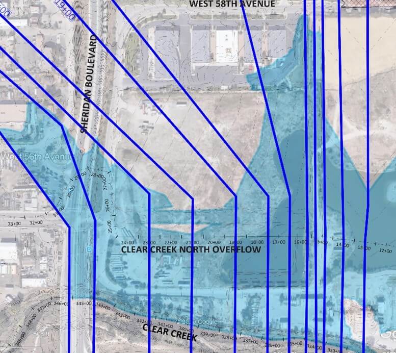
Floodplain analysis is used to determine the floodplain boundaries. While civil engineering firms regularly design stormwater management systems on development projects, most use existing FEMA floodplain maps and do not perform floodplain analysis. Analyzing the flow of water in and around a river can be very complex and is not always intuitive. At times additional flow in a river can actually lead a narrowing of the channel due to increased velocity and more efficient flow patterns. In other cases where flow is being forced through a constricted opening (bridges and culverts) a situation is created known as an inlet-controlled condition, the shape of the upstream channel can then be manipulated significantly without seeing an impact on the water surface elevation.
Tools and techniques can be employed in floodplain analysis to manipulate boundaries and create areas suitable for development. However, due to the engineering complexities, numerous regulations, and the FEMA permitting process, most civil engineering firms avoid doing floodplain work and hand it off to engineers who specialize in it.
VERTEX Has you Covered
VERTEX has a team that specializes in floodplain analysis and management, and we work with developers who have projects in defined floodplain areas regularly. Our team has developed techniques to modify land topography and river channel shapes that remove floodplain and increase developable area. These can be big projects, but when factored against the added land value, the associated engineering expense is a small investment.
Our floodplain engineering services including Hydrology & Hydraulic Analysis, Hydrology & Hydraulic Modeling, Flood Risk Management and Mitigation, Floodplain Analysis and Mapping, and FEMA permitting including CLOMR, LOMR, and LOMA submittals to support all aspects of land development. Our team can handle the floodplain management process from site grading, channel creation, and bank stabilization, to establishing new floodplain boundaries and coordination with Flood Management Districts, Municipalities, and FEMA
To learn more about VERTEX’s Civil Engineering Services, or to speak with a Construction Expert, call 888.298.5162 or submit an inquiry.
